Outdoor brand Merrell got in touch with us recently to share the news that they’ve partnered with the Royal Geographical Society to establish the Seven Natural Wonders of the UK – a list of natural landmarks that are unified by their shared beauty, uniqueness, and geological significance. It turns out the list they’ve curated, and the photography accompanying it, is actually pretty spectacular, so we thought it would be a good idea to share it all on with our lovely OM readers.
From the natural artistry of the Giant’s Causeway to the rugged beauty of Loch Coruisk & The Cuillins, each of their ‘natural wonders’ showcases the finest work of Mother Nature on these shores – landscapes carved out over millions of years that have stood the test of time through Ice Ages and intense volcanic activity.
What’s more, Merrell have also a curated a trail running guide to these seven beauty spots, with routes exploring each one mapped out on komoot so you can visit each one under your own steam. And hey – they might be designed as running routes, but there’s no reason why they won’t be just as enjoyable at a more leisurely pace.
1. Dovedale, Peak District
Nestled near the Southern reaches of the 1400km Peak District National Park and within easy reach of both Stoke on Trent and Derby, lies this absolute gem of a trail.
A circular route beginning and ending from the tiny village of Grindon, this route encompasses quintessential Staffordshire and Derbyshire landscapes; rolling meadows, single track trail through farmland and picturesque villages. And that’s not including the geological marvel that is Thor’s Cave, found a mile and half in (depending on which way round you tackle this loop).
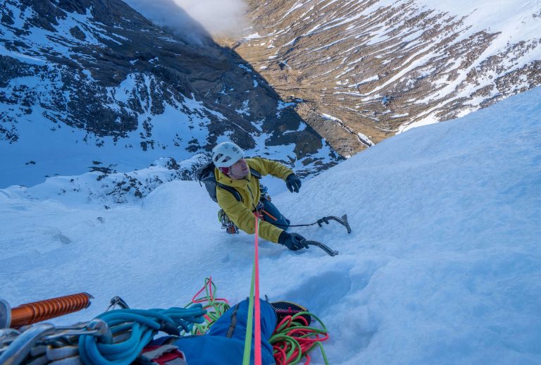
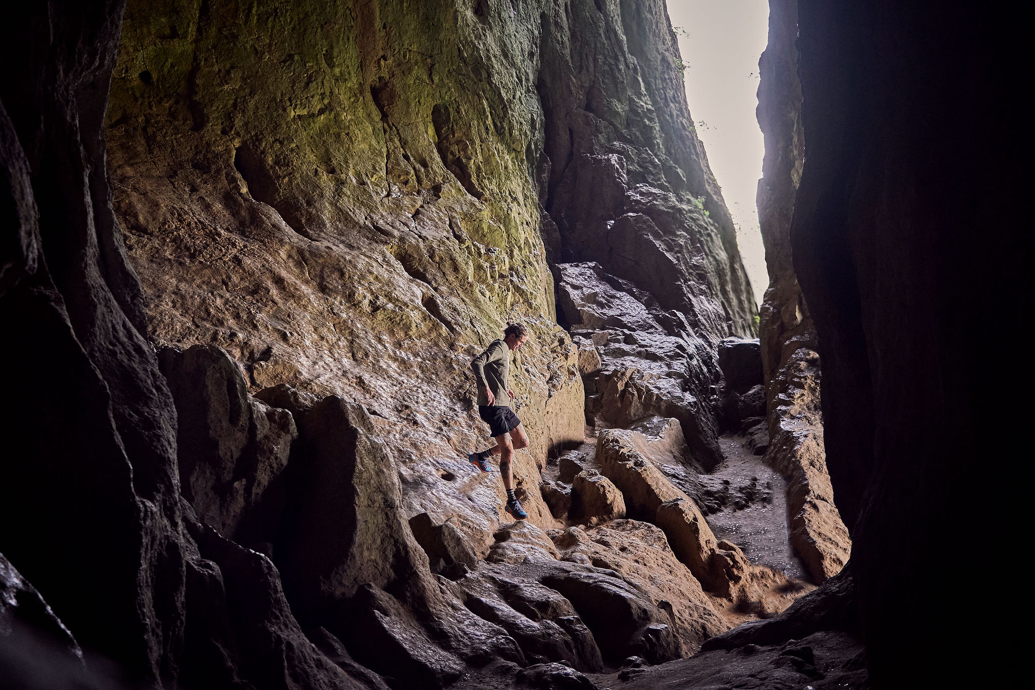
A natural cavern buried within a steep limestone crag, a huge arch marks the entrance to this jaw dropping feature in the landscape. Easily accessible from the valley floor, the going can get very slippery following wet weather, so take good care when exploring the steep sided interior. The views out over the dale are spectacular and if you’re as lucky as we were you might find a climber tackling the infamously difficult climbing route (an 8a if you were thinking of giving it a go) which spans the arch of the cave.
Exiting via either a miniature slot canyon (followed by a ridiculously steep ascent above the cave) or the more traditional route, the trail continues to gently descend and ascend throughout until reaching the Wetton Mill Tea Rooms, whereby you cross the River Manifold before closing the loop through orchards and farmland.
2. Wast Water, Lake District
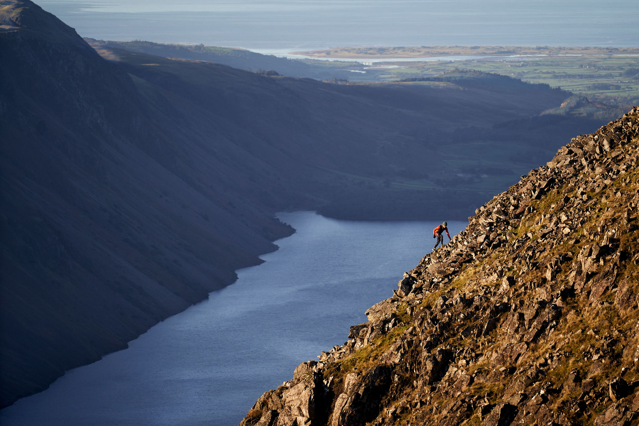
Surely one of the finest sights in all of the Lake District, if not the United Kingdom, especially when the sun shines and the skies stay clear for you.
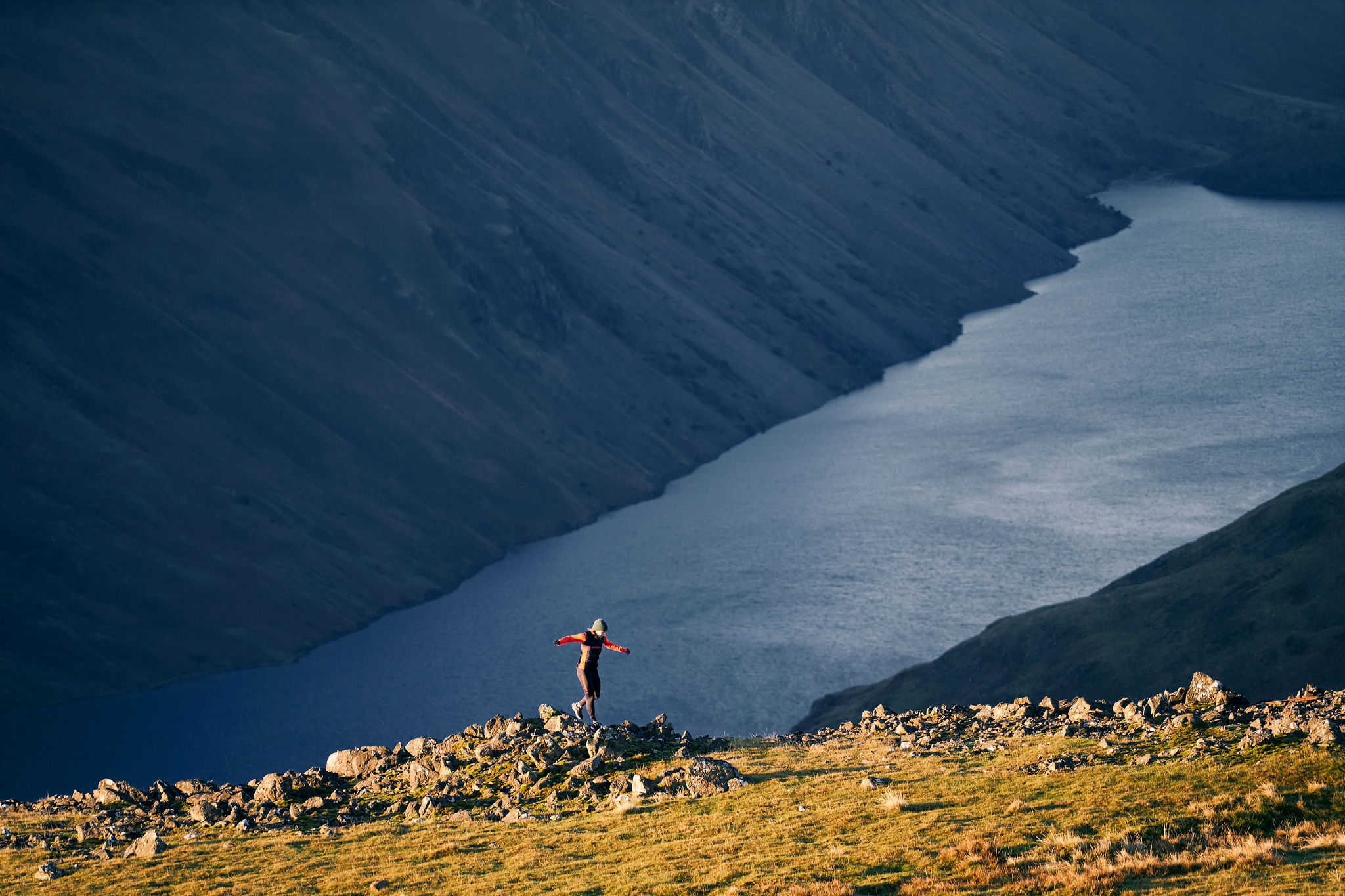
Wast Water, England’s deepest lake with its bottom lower than sea level (only 8 miles West at Seascale) is a valley in the Western part of the Lake District National Park, the UK’s second largest after the Cairngorms. Open to the elements, this part of the Lakes sees more of the prevailing weather than any other and as such is notorious for low lying clag, summit gusts and what often seems like scant opportunity to glimpse the fine summits of Great Gable and Kirk Fell, which rise above the head of the water to the East.
Your biggest decision might seem like which direction to tackle the nose of Kirk Fell, a relentless steep walk from the valley at Wasdale Head to the summit at 2,631 feet (802 m). Setting off ahead of sunrise it does at least offer the chance to warm the body up immediately; the alternative is a descent which tests the knees and quads of any runner but offers some fantastic (and in places technical) trail running. The option to link this Wainwright with Great Gable is there, should you have the legs for a short out and back from Beckhead Tarn.
Either way, when the reward is a pint of local ale by the fireside of the famous Wasdale Head Inn, these must rank as some of the finest Lakeland views out there. Just don’t forget your raincoat.
3. Giant’s Causeway, County Antrim
The most challenging part of running this stretch of Northern Ireland’s jaw dropping coastline? Getting round without stopping every 500m to take in the views. It’s not every day your trail runs through a UNESCO World Heritage site now is it?

Looking across to Scotland’s Kintyre peninsula as the North Atlantic Ocean pounds the rugged coastline a couple of hundred feet below, this trail offers something for everyone, including the geologist. Beginning at the mind-blowing Giant’s Causeway, where 40,000 interlocking basalt columns rise from the sea, there aren’t many words that can be found to describe the experience of leaping from column to column, aware that you’re treading upon the result of volcanic activity some 50-60 million years ago.
The Giant’s Causeway World Heritage Site extends roughly 3km from northeast to southwest and 0.5km from northwest to southeast at its widest. It occupies approximately 70ha of land and includes much more than the famous ‘stones’ alone, making this trail one to treasure. As you run East from the stones, the trail splits into an upper and lower path.
Whilst the lower path only continues for 1-2km before you reach a barrier protecting you from a collapsing cliffside, it is worth the effort just to see the wild landscape of the headland and bays. I’ve not been to the Faroe Islands but it bears a remarkable likeness from the Instagram shots I have seen!
The emerald green of the hillside, complete with scattered herds of sheep clinging to the hillside, contrasts beautifully with the burned red soil and as the trail rises and falls toward the ruins of Dunseverick Castle, you’re reminded what an incredible coastline the United Kingdom has.
4. Durdle Door, Dorset
Durdle Door is one of the Jurassic Coast’s most iconic landscapes. It is also high on the list of the most Instagrammed locations in the UK, but don’t let that deter you from experiencing coastal trail running at it’s very finest.

A natural arch, formed from a layer of hard limestone standing almost vertically out of the sea, Durdle Door is relatively easily reached assuming you have appropriate footwear (which 80% of visitors seldom do). This route begins and ends from the head of Lulworth Cove, alongside The Castle Inn (all runs/hikes should feature a pub at some point, preferably the end) and ascends on grassy farmland trail Westward. You may want to reverse the route depending on just how strong the prevailing Southwesterly is gusting that day, but at some point it is going to be in your face and that is the joy of this trail; exposure to the elements.
Aside from the static home park halfway, the views along the trail seem to just get better and better with a fine vista from the furthermost point near White Nothe toward the Isle of Portland and Weymouth Harbour. Ticking off some of the best landmark names going as you return in Bat’s Head, Butter Rock and Scratchy Bottom (I kid you not), the coastline seems to plunge and rise in an unforgiving manner until you return by Durdle Door, skipping around some of the 200,000 walkers that this stretch of the South West Coastal Path sees each year.
5. The Needles, Isle of Wight
The Needles, at the South Westernmost point of the Isle of Wight, are a row of three chalk stacks that rise up from the often turbulent English Channel. The lighthouse that sits at the furthest point has been a beacon of hope to sailors since the 19th Century, the bright white chalk cliffs that sit behind rise ominously and make this the most visited point on the IOW.

This gentle yet challenging trail takes in not only the Needles but some fine woodland park as you leave the charming Yarmouth Harbour, heading South and beyond the colourful beach huts of Colwell Bay. Climbing gently toward Headon Warren, the majesty of the chalk stacks reveals itself ahead of you, with mainland UK to your right. Passing swiftly by the bizarre tourist attraction (lest you choose to descend the steep stairs for a close up view of Alum Bay’s remarkable coloured and rapidly collapsing cliffs) the trail leads out toward the Needles and some remarkable viewpoints directly atop the chalk faces and Icelandic-like black beaches far below.
Once you have pulled yourself away the trail heads East toward Freshwater Bay, rolling along the Tennyson Trail where you can pick up the pace should you choose before heading North along the bank of the Western Yar, returning to Yarmouth ideally in time to make the ferry back toward Lymington.
6. Pistyll Rhaeadr, Powys
Whilst most runners head to the mountains of Snowdonia or rugged beauty of the Brecon Beacon’s when hunting for trails in Wales, the hugely underlooked Berwyn Mountains and 240ft high waterfall of Pistyll Rhaeadr ought to sit alongside them.

Whilst Britain’s tallest single-drop waterfall is worth the visit alone, it is the ease of access onto the Berwyn’s and a chance to bag over 1700ft in ascent across beautiful Welsh valleys and hill tops that rank this as a must-run trail.
At 832 metres (2,730 ft) above sea level the summit of Cadair Berwyn is the highest point in the Berwyn range, the highest in North East Wales and the highest significant summit in Wales outside the National Parks. On a clear day, views stretch to Snowdon, Brecon Beacons, both Peak and Lake Districts, Yorkshire Dales and incredibly the Isle of Man, making this a good spot to stop for a photo op if the rain isn’t coming at you sideways like it was for us.
The descent from Cadair passes a small lake, Llyn Lluncaws which, depending on the season is either a refreshing dip or an ice bath. From here, the trail opens up at a beautiful gradient for fast downhill running but don’t forget to take in the stone wall remains of a sheep farming outpost in the valley beneath, before returning to the waterfall.
7. Loch Coruisk and the Cuillins, Skye
Loch Coruisk, translated in Gaelic as “Cauldron of Waters” is located on the Isle of Skye and can be accessed via boat from Elgol or by foot, either from the Camasunary car park or Sligachan.

This route is from the Camasunary car park and has layers of views that are stripped back as you head towards the loch. From the car park, you slowly gain height along the rough track and are initially greeted with the tips of the Cuillins summits in the distance. Upon reaching the high point, the track then begins to weave down towards Camasunary Bay in Glen Sligachan. There is a stunning bothy located in the bay just by the beach, the perfect stopover If you wish to make this route an overnight trip.
Leaving this bay, you then cross Abhainn Camas Fhionnairigh, a river that requires a bit of scouting to find the best crossing. Once across, the ascent up to the summit of Sgùrr na Strì. The route up here has no path so watching your direction is key. Sgùrr na Strì sits at 494m. For the small amount of height gained, the view over Loch Coruisk is spectacular, and has been named as one of the best views in Britain.
From the summit, the loch sits nestled under the Black Cuillins, and to the left you can enjoy views over the Small Isles with Rùm and the Isle of Canna in the distance. Making your way down to the loch, the route is grassy and goes past large rock slabs and, depending on the weather, through boggy patches. Once at the bottom there is a trail that will take you left, along the water’s edge and back around to Camasunary Bay. While an easy coastal path to follow there is one feature, the Bad Step. This is a long crack in a rock slab that you traverse across with the blue waters of Loch nan Leachd below you. This traverse isn’t for the faint hearted and requires some scrambling to negotiate the way across.
Once back at Camasunary Bay, you cross the river again and follow the same route back to the car park taking in the views that were behind you on the way in.
You May Also Like:
Britain’s Best Bikepacking Routes