Viewranger isn’t the only GPS mapping smartphone app out there, but in our experience, it’s the best one out there with a huge spread of features and an ongoing development programme which means it’s continually being upgraded and improved.
It’s hard to give a price here as the app itself is potentially free, but you pay for Ordnance Survey mapping, either in the form of individual tiles or as more conventional pre-packaged area maps like National Parks, so costs depend on how much mapping you need.
Tech Dump
The most commonly asked question about smartphone apps is whether you need a data connection to use them. In the case of ViewRanger and most others, the answer is no. The phone’s built-in GPS works regardless of you having a signal and the mapping itself is cached on the phone, so there’s no need to have a data connection.
You can even cache free to use mapping like Open Streetmap for use in the field. The big plus of having a data signal or wireless connection is that you can buy mapping as you need it using prepaid credits in the Viewranger store.
And once you’ve bought a map on one device, you can use it on another – you could, say, run the app both on an iPhone and an iPad, but you only pay for the mapping once.
Performance
We’d choose the Viewranger app over most stand-alone GPS units for a number of reasons. First, you have a phone anyway, so it’s one less item to carry with you. Next, the interface, which has been rehashed for the current version 4.0 on both iOS, Blackberry and Android, is excellent, clean, clear and easy to use with straightforward access to a huge spread of features which equals or exceeds most stand-alone GPS units.
Then there’s the superb connectivity. You can buy and download mapping on the fly, even on the hill as you go if you have a signal – and yes, we’ve done it – but you can also download routes free or paid for using the Viewrange store and selected foreign mapping as well.
That’s not all, by signing into the MyViewranger web site, you can synchronise all your devices and upload and share your tracks and routes.
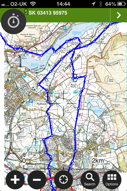
Finally, the reproduction of OS mapping is superb on a smartphone screen, clear, bright and fast-scrolling, panning and zooming. It makes most mapping GPS units looks a bit sad.
All of which means in use it’s excellent. Recording tracks and following routes, even planning them on the device – an iPad or similar tablets is a good call for this – is straightforward as is checking out graphs and charts of your saved tracks and viewing them on the map. You can also access OS maps on My Viewranger and plan and export routes from there.
Finally, there’s a unique Buddy Beacon position which allows you to share your position on the map with other ViewRanger users in real time. Great for group use, for letting loved ones check on your position or sharing via the My Viewranger web site.
We’ve been using the software on and off for several years now and it’s done everything we’ve asked of it and it’s steadily improving.
It’s not quite perfect. Power handling has improved gradually over various releases and is now acceptable, but GPS makes harsh demands on phone batteries, so it pays to use the app’s settings to minimise power use, to reduce screen brightness and ration use slightly. You might also consider carrying a back-up battery or power source just in case.
You also need to consider protecting your phone with some sort of weather-resistant case. In general, stand-alone GPS units tend to be more rugged than phones albeit often heavier.
Verdict
If you own a smartphone, Viewranger is an excellent way of converting it into a fully-featured GPS navigational tool with clear, easy to read OS mapping. It’s straightforward to operate, accurate enough to cope with general outdoor use and has brilliant connectivity allowing you both to buy and download mapping as long as you have a connection or wireless network and to synchronise and share your own data.
It’ll track your walks, runs or rides, allow you to download and follow other people’s routes or plan your own and display the vital stats in chart and graph form, you can even use it to share your position in real time via Buddy Beacon. Finally, the My Viewranger web site is an excellent resource with its own OS mapping and ability to plan and share routes.
You do need to be aware of the tendency of GPS apps to eat battery power, but with careful use and a back-up power source, that needn’t necessarily be a serious issue at least for single-day use.
Just an all-round brilliant navigational app.