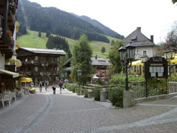
Saalbach Village and Amenities
 |
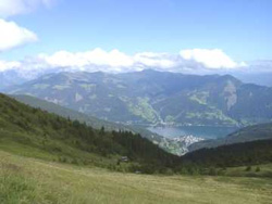 |
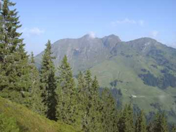
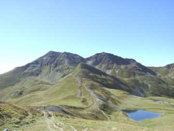
Saalbach (1000m) lies in the Glemmtal a few miles west of the lake resort of Zell am See. Saalbach is in the province of Salzburgland. The Glemmtal is a small valley that runs from east to west, the two main villages in the vallley are Saalbach and Hinterglemm. There is road access from the east end of the valley only.
Saalbach is a spread out, with some areas climbing into the hillside. Some of the accomodation is several minutes walk away from the centre and the main facilities.
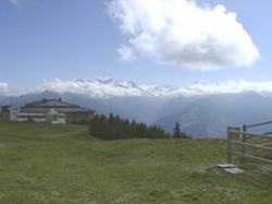
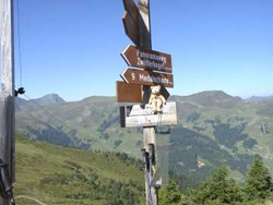
In the centre of the village there are couple of streets that contain most of the shops, cafes and banks. There is a small village square with a bandstand and the church is situated just off the square. Some of the central area is pedestrianised as traffic goes along the main road on the edge of the village. On the main road which follows the river is the tourist office where you can get information about walks and walking badges. There are two cable car stations, one is is situated on the main road and the other is situated to the north of the village square.
There are four supermarkets throughout the village, one is situated in an old building in the village square. The post office is in the village square. There is an outdoor public swimming pool along the main road about 10 minutes walk from the centre, this was closed whilst we were there.
We stayed at the Alpenhotel a 4 star hotel in the centre of the village, only a few minutes walk from the cable car stations and bus stop. We had a very nice room with balcony at the back of the hotel, with views of the church – beware the 7am wake up call from the bells! It is a large hotel which has a lot of facilities including its own conference suite. When we were there it was very quiet and so lacked buzz. The food was reasonable but we did not enjoy the evening meals as much as we have in other Austrian hotels, again this may have been because it was quiet. The hotel has a leisure area which includes a small indoor swimming pool.
One couple we met, used Inghams to do the flight and transfer, but picked their own hotel. The reps were very helpful to them. They have done this for many years, and would recommend it. You don’t necessarily save money, but you do have the opportunity to negotiate rooms that suit your requirements (more space, better TV, etc), and may include better meals e.g. 5 courses instead of 4. It is something we would consider doing ourselves in future. This couple were comfortable with leaving booking till a few weeks before their holiday. Another piece of advice was to double check whether it would be worth doing transfer yourself – hotels are often very accommodating and will pick up from local bus or train station. The final advice was to ring round the different tour operators as options and costs varied by year, and closeness of departure date.
Our holiday was with Inghams. You could make your own arrangements and drive there or fly to Salzburg, then train to Zell am See and Post Bus to Saalbach.
Transport
There is a Post Bus to Hinterglemm and the end of the valley at Lengau, and down the valley to Zell am See. It is a hourly service with buses running into early evening. The main bus stop is situated outside the Schattberg Cable Car station.
At Lengau there is a tractor train, called the “Noddy” Train, which runs further up the valley to Lindlingalm. This connects with the bus service.
There are four cable cars in the valley that are open in summer.
The Schattberg X-Press goes from Saalbach to the top of the Schattberg mountain (2018m) on the south side of the valley.
The Kohlmais lift goes from Saalbach to the top of Kohlmais (1794m) on the North side of the valley.
The Zwolferkogel lift which goes from Hinterglemm to the top of the Zwolferkogel (1984m) on the South side of the valley.
The Reiterkogel lift which goes from Hinterglemm to the Reiterkogel Middle Station on the North Side of the valley.
There is also the Schmittenhohe Lift which you will need to use if you do the Panaroma walk over to Zell am See.
All the lifts runs daily from about July to late September, some of the lifts run from the end of May to the beginning of October.
There are a couple of passes that you may consider buying.
One is the “Alpine Pass” valid for 5, 7 or 12 days. This pass covered the use of all the four cable cars, local bus up to Lengau and down to Jausern, the “Noddy” train, and use of the public indoor and outdoor pools. It also covered one trip on the cable car between Schmittenhohe and Zell am See. The other pass is the Wandercard which covers unlimited use of the four cable cars for 2 days in 5, 4 days in 7 and 8 days in 14 days. We bought the 12 day Alpin Pass.
Walking
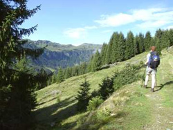
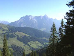
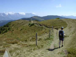
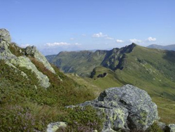
Saalbach is a very good walking area. It certainly exceeded our expectations, we had booked the holiday with a degree of uncertainty about the suitability of the resort for two weeks walking. The resort is good for all levels of walking. All our walks except one started and finished in the valley, the exception being the walk over to Zell am See. The hills and mountains around the valley are not that high and this means that you can walk to the tops and along ridges. The height also means that there are no permanant snowfields or glaciers. We found the top (western) end of the valley particularly attractive with some excellent peaks to climb. There are quite a few mountain inns and restaurants around, but they tend to be lower down and on some of the walks we did there were none except at the start and the finish of the walks. The bus service and cable cars means getting around the valley is easy. The main problem with the transport is that some of the lifts closed around 4pm, earlier tham we would have liked.
All the walks that we did were covered by the Saalbach Hinterglemm Wanderkarte at a scale of 1:25000 published by Mayr, this map was obtainable locally. Kompass map 29 at scale 1:50000 “Kitzbuheler Alpen” and Kompass map 30 at scale 1:50000 “Saalfelden Leoganger Steinberge” cover a larger area and are useful if intending to do walks ourside of the Glemm Valley.
There are local walking badges. The stamping books are available at the tourist office. The badges work on a points system which required walking to summits and huts etc. We managed the “Gold Rucksack with Diamond” the hardest of the badges to get. This wasn’t planned, but we realised near the end of the holiday that it was within our reach. We are both a bit fanatical about the badges, though once home they are tucked away. we could have made it easier on ourselves as some stamping points appeared more than once, but we insisted on a revisit for the second stamp.
Walks we did from Saalbach (1000m) and the Glemm Valley
Wetterkreuz
29/08/2004 – having collected our KontrollKarte Wandernadel from the tourist office, we did a circular from our hotel, worth 30 points towards our total. The tricky bit was finding our way out of the village and on to the Pascherweg. This was a delightful path that led up to the Spielberghaus ( 1319m – 10 points, and our introduction to the clippers) and our first beer of the holiday. This was not the brightest of ideas, as we still had over 400m of climbing. Unusally for Austria, after the initial zig zags, the path led directly up the hillside. We had started in sunshine, but it was now cloudy and by the time we got to the first top (Bernkogel 1740m) we had our cagoules on, but still had good views. We dropped towards Wetterkreuz (1663m – 20 points) which was marked by a wooden cross. We then followed path 13 (some track, some path) down to Saalbach. On the way down we got caught in a thunderstorm, and so arrived back at the hotel with clothes and rucksacks dripping. Luckily all the gear dried overnight on the balcony.
Spieleckkogel (1998m)
 |
 |
30/08/2004 – Today’s walk was along a grassy ridge on the north side of the valley. We began with the postbus to Lengau, followed by path three towards Spieleckkogel. The path numbering system was a little odd, as there were at least three paths numbered three! The path led up through trees until we mislaid it in the heather and bilberry bushes. After some searching we found it, and headed upwards to the summit of Spieleckkogel (1998m). Views from the top were superb – grassy hills to either side, northwards to the limestone ranges, and south to the snow capped Gross Glockner range. We walked along the ridge to Reichkendlkopf (1941m – 25 points), As an optional extra we bagged the Hochalmspitz, where there was a modern memorial cross to a local doctor, before heading down on path 4, collecting a drink at Rosswaldhutte, reaching Hinterglemm just in time to see the bus disappearing! As the buses were every hour we walked back to Saalbach – this would be very pleasant taken at a gentle pace! It is a made up path, and so very tough on hips if you are expected to do it fast! (Dennis wanted an ice cream and swim before the evening meal.)
Stemmerkogel
31/08/2004 – A damp day to start, so we spent some time checking out the walks we wanted to do during the holiday, and brought the 12 day Alpine Pass. We then took the Schattberg Xpress to the top of Ostgipfel and ambled towards the Stemmerkogel. As we approached the cloud lifted for a short while, so we could see the top. We kept catching glimpses of the mountains through the clouds. At the summit we stamped our cards (25 points) and then on the way down we met what looked like a herd of highland cows! Further on, at the Limbergalm (20 points) we met the Bluebell group (from the North East) – with several people in shorts – whereas we were well wrapped up against the weather. We continued down a very pleasant path towards Jausern , which later followed the piste. At Jausern we caught the bus back to Saalbach. An easy and enjoyable day, making the most of a not so good weather day.
Pinzgauer Spaziergang
 |
 |
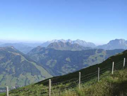
01/09/2004 – The Pinzgauer Spaziergang is a high level footpath that runs along the ridge that seperates the Glemm valley from the Pinzgau valley. The section from Saalbach to Zell is a popular day walk and is well signed.
We started from Saalbach Schattberg Xpress top station, as the Zell-am-See gondala was open to 5pm, whereas the Schattberg Xpress stopped at 4pm. Our travel pass covered the cost of the Zell-am-See gondola. At our pace the walk took about 6 to 7 hours, and so we needed to keep our stops fairly short. There are shelters, but no refreshment stops apart from the gondola stations, so take plenty of liquid. Anybody feeling fit can divert off the main path at various points to bag some of the tops. The main path contours below the peaks on the ridge generally staying around the 1900m contour. The total ascent (we did not do any tops) for the day was under 600m.
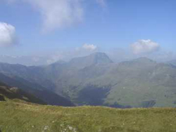
We were blest with sunny weather, and so had excellent views of the Grossglockner range to the south. From the top station we followed the path south, over to the west there was good views across to Geisstein, the highest mountain in the Glemm valley. After a while the path comes to a small lake at Seetorl. From here the path contours around the slopes of Hochkogel, and path rejoins the ridge at Klingertorl (2059m).
The path continues conturing below the tops on the ridges, past a couple of shelters marked on the map as Unterstandhutte. The one at Klammscharte is just over half way, and contains the stamp (35 points). The path continues on towards Schmittenhohe.
There is a sting to the tail as there is a 200m ascent at the end of the walk to reach the cable car station at Schmittenhohe. From here there are good views down to Zell and the lake.
From the base station it is a good 20 minute walk to the central bus station, where you pick up the bus to Saalbach. We missed the bus by a few minutes, and so had an hour to spareand ambled down to the Lakeside. The bus back to Saalbach was not covered by travel pass, but it was only a few euros.
Tristkogel (2095m)
 |
 |
02/09/2005 – Today’s walk was at the head of the valley, this proved to be an excellent walking area. We took the bus to Lengau, and then walked along the road to the Noddy train, glimpsing Tristkogel in the distance.
We took the Noddy train to Lindlingalm (1310m), and then took path 2 past the Ossmannalm, and up to the Saaljoch. From here we stayed on the main path for a while, before taking a small but marked path up the east ridge of Tristkogel. The path was steep at first, but levelled out towards the summit, there was a short section which some people (Jackie did) might find exposed. We soon reached the summit, which is marked by a metal cross.
We took our time reading the summit book. The views were supberb. We descended on the main path down the west ridge and walked towards Hochtorsee, looking back we had many good views of Tristkogel.
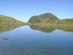
At the Hochtorsee we were disappointed to find that the stamp was broken, but claimed our 40 points anyway. The Hochtorsee is the largest of the mountain lakes in the area. This view of Tristkogel from the lake is a classic shot that is used on many postcards.
From the Hochtorsee we returned to the Lindlingalm on the path that passes the Pfandebenalm. This was a longer route than we expected, but we were in time for the Noddy train and connecting bus.
Saalachtal Hohenweg
 |
 |
03/09/2005 – This walk was another high level route. This path is on the north side of the valley and it runs is along the ridge that seperates the Glemm Valley and the Leogang valley. The ridge is lower than that followed by the Pinzgauer Spaziergang, and is forested along most of its length.
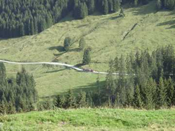
We started by taking the cable car to the Kohlmaiskopf (1794m), and we were soon enjoying good views to the north as we made our way past the Brankogel (10 points) on to the Grune Boden Hutte (20 points). The path was lovely up to Wildenkarkogel, but the middle section to Gr Arsitz, and onto Geierkogel was disappointing due to the impact of the skiing developments. Although Saalbach is a relatively low resort, the absence of rocks means only 20cm of snow is required for good skiing. Once past the middle section the ridge was very pleasant. When we reached Geierkogel (1853m), we had a good view from the summit.
After Geierkogel we enjoyed the walk a lot more – dappled sunlight and forest – one of Jackie’s favourite combinations. We collected another stamp (10 points) at the Geierkogelhutte, before the long walk out to our final stamping point of the day Durchenkopf (10 points).
Shortly after leaving Durchekopf we left the main route to pick up the Alpenrosenweg, which we had to ourselves. Lovely paths led us through forest with occasional views. Finally we reached Jahnhutte for a welcome drink.
The last section was forest track, which we did at quite a speed, down to Viehhofen and the bus stop.
Talschluss Hohenweg
04/09/2005 – wet today, so a low level walk at the top end of the valley. Took the bus to the terminus at Lengau. Rather than take the Noddy train, we decided to walk up to the Lindlingalm to “earn” our stamp and 10 points. We then followed the Talschluss Hohenweg around the head of the valley, passing an interesting carving on the way!
We were disappointed to find that the stamp was missing from the control point, so we ticked and dated our card. The cloud had started to lift and we had views down the valley. Returning to Lengau we followed the river path down the valley for twenty minutes before catching the bus back to Saalbach.
Spielberghorn (2044m)
 |
 |
05/09/2005 – Back to sunny weather again today. As the bus services were not as frequent on a Sunday, we decided to do a circular from Saalbach. We took the cable car to the Kohlmaiskopf to start, took the path to the west, and were soon rewarded by views of the Spielberghorn. We walked west along to the Barnkogel shelter (10 points), and then down to the Spielbergtorl. We then contured around the slopes of the Spielberghorn, and down to the col below the Kleberkopf.
From the col we walked to the summit of the Kleberkopf (1757m – 20 points) and then retraced our steps to the Spielbergtorl, and took the path to the summit of the Spielberghorn (2044m -35 points). As it was a sunny Sunday, lots of people were out walking – which made some of the tricky bits more awkward. From the summit most people descended by the same path, but as we had plenty of time we decided to walk “around the back of the mountain”. An excellent choice – although very tired by the end, we had much of the mountain and the marmots to ourselves.
We walked along the ridge to a col before the final top and looked down into an enclosed valley which would be our descent route. Continuing down and round the moutain, after loosing about 300m of height we picked up a path crossing the lower slopes of the south side of the Spielberghorn. This seemeded to take ages, but eventually it started upwards towards the Spielbergtorl. Once we reached the col we took path 14 back to Saalbach.
We had really enjoyed the walk today, although it had been pretty tough (some whinging in the party!) with the climb back up to the col at the end.
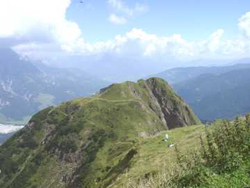
Panorama Walk
 |
 |
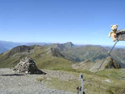
06/09/2005 – The Panorama Weg is a high level walk that links the top station of the Schattberg Xpress with the top station of the Zwolferkogel Lift. Because of the operating times of the lifts, the walk has to be completed in approximately 7 hours, unless you do not mind the descent from the ridge at the end of the day. This is a pity, as we were always concious of the time, and this detracted from what is a very enjoyable walk. It took us 6.5 hours but the bergfuhrer only allowed his party a few brief stops, this did cause some dissent in the ranks!
We were on the lift as soon as it opened (which was a little earlier then scheduled), and started walking from the top Station (2018m), enjoying the freshness and views. We walked down to the col below the Westgipfel. However we could not go up the track as it was closed for maintenance, so we took the path over the Mittelgipfel to the Westgipfel (2096m – 10 points) for our first stamp of the day. We then continued south along the main ridge to Seetorl. Here we took the path going west.
The path crossed the Baumoosriedel ridge, it then contured along the slopes until it climbed to meet the main ridge at Sommertor (35 points). We had a short break here and something to eat, before continuing on to Stoffennieder (25 points). From Stoffennieder we walked along the ridge going north over Schonhofer Wand (2116m) which was the highest point on the walk. We stayed on the Panarama Path which skirted around Hoher Penhab before finally reaching the end of the Walk at Zwolferkogel (10 points). We caught the lift down to Hinterglemm and rewarded ourselves with a glass of wine and ice cream before catching the bus back to Saalbach.
Staffkogel (2115m) and Sonnspitze (2062m)
 |
 |
07/09/2005 – Staffkogel and Sonnspitze are two peaks at the head of the valley. This was a very pleasant walk, and one of our favourites from this holiday.
We caught the bus to Lengau, and Noddy train onto Lindlingalm (1310m). From here we took the track to the Ossmannalm, and then onto path 3, a very pleasant path winding between the trees. Once path came out into the open it climbed gradually to join the main ridge at the Oberreiter Joch.
From this col we walked up the path leading to the summit of the Staffkogel. We descended down the same path for a short while, before turning off on the path which led to the Henlabjoch. This col at 1860m is one of the lowest crossing points in this part of the valley. A path leads west from here towards Kitzbuhel. This is a walk that we did not do – its possible to get a taxi back, and sometimes the walk is organised by the tourist office.
From the col we walked up to the summit of the Sonnspitze. Finally We returned to the Henlabjoch, and then took path 3 down to Lengau, with a good aerial view of the Noddy train.
Grune Boden Hut
08/09/2005 – After yesterday’s walk we had accumulated enough points to merit the Gold Rucksack badge. However we then decided to go for the Gold Rucksack with Diamond badge. This required 600 points, looking at the stamping card the only way we could achieve this would be to climb the Geisstein and the Hochlogel, and to revisit the Grune Boden Hutte. One of the pecularities of the walking badge was that some clipping points could be revisited.
We decided to start with the easiest. So we took the cable car to Kohlmaiskopf and walked east along the main path to the Grune Boden Hutte (20 points).
We continued along the main path before cutting off down grass slopes to find a path which joined up with path 17. This was very pleasant, and led to the Schonleitenhutte – more like a hotel than a hut. From here we took path 11 and path 17 down to Jausern for the bus back to Saalbach. The way down was disappointing as it was a wide forest track most of the way.
After a leisurely afternoon and evening meal we visited the local Pumpkin Festival in the pedestrianised area. This brought many people out to enjoy the music and beer/schnapps.
Geisstein (2363m)
 |
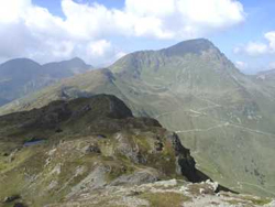 |
09/09/2005 – Geisstein is the highest peak in the Glemm valley is the toughest to reach. It takes about 4 to 5 hours from the top of the Zwolfergogel cable car. And then several more hours to return, in our case to Lengau.
From the Zwolergogel We walked along the ridge over Hoher Penhab and Shonhofer Wand, with excellent views of the Geisstein and our way ahead. We reached Stoffenieder and stamped our card here for the second time (25 points). We then walked West along the main ridge over the Mittagskogel, where we had a good view of the Geisstein and our route up the south east ridge.
We continued along the ridge to the Leitenscharte, and then followed the path climbing steeply onto the grassy ridge leading to the summit of Geisstein. We stayed on the summit a while, stamping the cards (40 points), signing the summit book, and taking in the views. We then started our descent back down the ridge to the Leitenscharte.
From the Leitenscharte we took the path then track down into the Vogelalp valley and followed this back to Lengau, where after a bit of a rush, we caught the bus with two minutes to spare. If you had more time and energy, then a more interesting route to Lengau would be via the Schusterscharte.
Hochkogel (2249m)
 |
 |
10/09/2005 – Hochkogel is a distinctive peak situated on the main ridge at the junction with the ridge leading north to Schattberg.
We took the cable car to Schattberg OstGipfel (2018m) and walked along the Pinzgauer Spaziergang to Seetorl, with a good view of Hochkogel ahead. From Seetorl we took Path 9 leading us onto the summit of Hochkogel, where yet again we enjoyed excellent views.
We clipped our cards for the last time to reach a total of 605 points, enough for our Golden Rucksack with Diamond badge, before retracing our steps to Seetorl, and the path to the Hackelbergalm. Here we celebrated with a drink and a Kaiserschmarren.
Finally followed the track down into the Waxeggraben valley and onto Hinterglemm for the bus home.